


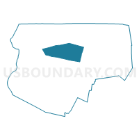
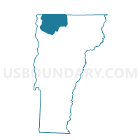
Sheldon Voting District, Franklin County, Vermont
About
Outline

Summary
| Unique Area Identifier | 680803 |
| Name | Sheldon Voting District |
| County | Franklin County |
| State | Vermont |
| Area (square miles) | 39.54 |
| Land Area (square miles) | 38.81 |
| Water Area (square miles) | 0.73 |
| % of Land Area | 98.15 |
| % of Water Area | 1.85 |
| Latitude of the Internal Point | 44.89858290 |
| Longtitude of the Internal Point | -72.92138990 |
Maps

Graphs
Select a template below for downloading or customizing gragh for Sheldon Voting District, Franklin County, Vermont


Neighbors
Neighoring Voting District (by Name) Neighboring Voting District on the Map
- Enosburg Voting District, Franklin County, VT
- Fairfield Voting District, Franklin County, VT
- Franklin Voting District, Franklin County, VT
- Highgate Voting District, Franklin County, VT
- Swanton Voting District, Franklin County, VT
Top 10 Neighboring County Subdivision (by Population) Neighboring County Subdivision on the Map
- Swanton town, Franklin County, VT (6,427)
- Highgate town, Franklin County, VT (3,535)
- Enosburg town, Franklin County, VT (2,781)
- Sheldon town, Franklin County, VT (2,190)
- Fairfield town, Franklin County, VT (1,891)
- Franklin town, Franklin County, VT (1,405)
Top 10 Neighboring Place (by Population) Neighboring Place on the Map
Top 10 Neighboring Elementary School District (by Population) Neighboring Elementary School District on the Map
- Swanton School District, VT (6,427)
- Highgate School District, VT (3,535)
- Sheldon School District, VT (2,190)
- Fairfield School District, VT (1,891)
- Franklin School District, VT (1,405)
Top 10 Neighboring Secondary School District (by Population) Neighboring Secondary School District on the Map
Top 10 Neighboring Unified School District (by Population) Neighboring Unified School District on the Map
Top 10 Neighboring State Legislative District Lower Chamber (by Population) Neighboring State Legislative District Lower Chamber on the Map
- Franklin-2 State House District, VT (9,167)
- Franklin-6 State House District, VT (8,940)
- Franklin-5 State House District, VT (8,617)
- Franklin-4 State House District, VT (4,103)
Top 10 Neighboring State Legislative District Upper Chamber (by Population) Neighboring State Legislative District Upper Chamber on the Map
Top 10 Neighboring 111th Congressional District (by Population) Neighboring 111th Congressional District on the Map
Top 10 Neighboring Census Tract (by Population) Neighboring Census Tract on the Map
- Census Tract 101, Franklin County, VT (7,130)
- Census Tract 105, Franklin County, VT (6,427)
- Census Tract 102, Franklin County, VT (4,473)
- Census Tract 104, Franklin County, VT (3,213)
Top 10 Neighboring 5-Digit ZIP Code Tabulation Area (by Population) Neighboring 5-Digit ZIP Code Tabulation Area on the Map
- 05478, VT (14,449)
- 05450, VT (4,977)
- 05459, VT (2,156)
- 05457, VT (1,617)
- 05483, VT (1,303)
- 05455, VT (1,080)
- 05485, VT (93)